
Since our plan was to visit five national parks, we bought an annual pass upon entry to the first one (the Grand Canyon). This covers all national parks for one year and cost eighty dollars. For reference, Grand Canyon, Bryce Canyon and Zion Canyon would have cost $25 each for entry (the other two were cheaper). Without the pass, we would have spent around $100 total for the national parks we visited. Take this into consideration when planning your own holiday!
We landed in Las Vegas around lunch time, picked up our rental car, installed the child seats and headed straight for Boulder City and Hoover Dam. We got there at 2:30pm, and found it impossible to park until we'd driven up to the unofficial gift shop and refreshment stop overlooking the Dam. We had an ice cream and appreciated the view for half an hour, by which time we could see plenty of spaces opening up in the various car parks.

Be warned that the Dam is busy--and the tourist season had barely started! Driving across it is difficult with all the pedestrians and the car parks get increasingly far away. The best place to park (if it has spaces) is the multi-storey car park on the Nevada side of the dam.
 |
| The most beautiful multi-storey car park I've ever seen. OK, the only beautiful multi-storey car park I've ever seen. |
As evidenced by the above picture, much of the Dam's associated buildings are gorgeously art deco, which was probably the main appeal for me. My husband was more fascinated by the engineering aspect, which our son was interested in as well, though most of it went over his head. Whatever interests you, the sheer scale of it all is incredibly impressive.

These winged statues were gorgeous, but don't forget to look on the ground around them for a map of the stars as they were when the Dam was dedicated.
You can walk over the dam for nothing, but to get the best view you have to get a ticket to access the terrace above the visitor's centre. There are also two tours, one of which has a lower age limit of eight. We signed up for the other tour, which all ages could attend and consisted of a short film (which bored both our children) and a ride down to two lower levels of the dam and its tunnels.

We were able to take our stroller on this tour, though at one point we were asked to leave it to one side as we went down a short flight of steps into the room. The guides were pretty cheery, well-organised and their script did a good job of putting the scale of the operation into perspective. However, it was too much for the kids to follow, and we had to keep them quietly distracted during the talking bits. They did enjoy seeing the tunnels and getting our whispered explanations of what the dam did.
After the tour, we were let into the main part of the visitor's centre with its museum and afore-mentioned terrace. Our children enjoyed both of these, so I definitely recommend paying for entry, even if you don't splurge on a tour.
 |
| The Memorial Bridge (Hoover Dam Bypass) as seen from the terrace. |
On the Nevada side, between the interstate and the dam itself, there is an access point for the pedestrian walkway across the Mike O'Callaghan-Pat Tillman Memorial Bridge, which carries the interstate across (900 feet above!) the Colorado river. We didn't have time to do this on our initial visit, so we actually took the time to go back there the evening before we left.
The walkway is free and has several plaques explaining the history of the bridge. The children were particularly taken by the ones spaced at intervals along the rail, depicting the bridge at various stages of construction. After seeing the congestion on the road along the dam itself, my husband and I were shocked to learn that this bypass only opened in October 2010! The apex of the bridge is marked by a bronze sign in the ground and so is the stateline between Arizona and Nevada.

Please note that the pedestrian walkway comes to a dead-end. There is no car park or access to it on the Arizona side. You walk across, and then you walk back again. Don't plan on piggy-backing your children either, as the railing is not very high (it is fully stroller accessible though!). The bridge is definitely not friendly to people with vertigo. You can feel the vibrations of the trucks going by, and if you hold onto the rail, you can feel every vehicle shaking through the bridge as it crosses. There's also no shade. We went at 4pm and figured that between the altitude and wind, it would be a cool enough walk, but we were all hot and sweaty by the time we were done.
Definitely worth doing, regardless. Due to the walls around the road, you will not be able to see the Dam or appreciate the view by just driving across.
 | |||||
| View of the Dam from the Bridge |
From Hoover Dam we drove to Williams for the night. We had set Williams as our goal, but it was a case of seeing how far we could go. In an ideal world, we would have liked to stop at Tusayan, right outside the Canyon, but we weren't going to push ourselves. Williams is less than an hour from the Canyon and is the starting point for the Grand Canyon Railway. We were in Williams for less than twelve hours, so I can't really speak for its tourist attractions, but driving through it we saw a small wild-west area, and I would have liked to have shown the children the station if we had time. If we'd had time (and it had been open) I would have liked to have done the railway too, though it doesn't seem the most efficient way of seeing the Canyon, giving you only a few hours there.
I used this unofficial guided tour webpage to take ourselves through the Canyon, although I misread it and assumed the rim trail between Yavapai Point and Grand Canyon Village was only 3/4 of a mile, when it was actually closer to 1.5. Oops! This was only a problem because we'd left the car at Yavapai, intending for one of us to run back there later and bring it round to pick up the rest of the family. We still followed that plan, but it took a little longer than we had envisioned.
It would probably have been smarter to do it in reverse, since my husband had a real struggle finding parking in Grand Canyon Village by that point, though chances are that Yavapai Point would not have had any spaces at midday either. My recommendation would be to do the rim trail between the two, but get the free shuttle back to the car!
 |
| View from Mather Point |
Our first stop was actually Mather Point, which provides a great view of the canyon and is well-fenced. As a bonus there are rocks sprouting through the paved ground at the Point, letting our children have some entirely safe scrambling and climbing.
At Yavapai Point there is a small geological museum and bookstore, situated right on the rim. A large panoramic window takes up one side of the building with binoculars and signs pointing out the visible features of the Canyon (it's one of the few spots from which you can see the Colorado River at the bottom).
From there we started the Rim Trail. This is fully paved and stroller friendly, though at some points the path forks, with a wheelchair sign pointing down the easier route. We always went on the other, more scenic path, and managed just fine with our stroller, but it could be awkward with a heavier one, due to some steep inclines. The trail itself has no significant barriers between you and the drop off--most of the time you're several yards from the rim, but at a few points you're right alongside it. Decide for yourselves how much you trust your children, and lay down any groundrules before you set out!
 | ||
| There are numerous places along the way for the "Aargh, I'm slipping!" photo op. |
We can't speak for the whole Rim Trail, but the stretch between Yavapai Point and Grand Canyon Village was interesting, with lots of info about the Canyon's geology at regular intervals. There were lumps of large rock on display along the path, which were a good early distraction for our ever-hands-on children. They also had a million year walk feature, walking you through a million years of geological history via numbers set into the ground. This then became a 2000 million year walk, finishing at the Grand Canyon Village itself. Finding these numbers and counting down how many were left to go were what got our son through the last half-mile or so.
Halfway through the walk, our daughter pooped. We found a flat rock discreetly off-trail (checked for snakes first) and changed her, popping the soiled nappy into our rather full stroller basket to dispose of at the Village. When we arrived, we discovered that the nappy had fallen out along the way. I was utterly mortified. My husband found it when he walked back for the car and disposed of it properly, but countless people would have passed it before then, and to them, I apologise.
The Village itself was tougher to navigate than we had anticipated. There were numerous lodges to trek past before we got to shops and refreshments. (We'd promised the children an ice cream when we got to the village, and while it was probably less than half a mile from the outskirts of the village to the centre bit, it felt much longer than the Rim Trail.) It was also hot and busy.... I'd hate to see what it's like in the summer.
That said, Lookout Studio has a breathtaking tiered terrace going over the edge of the Canyon. My daughter was fussing too much for me to get her down there, but I stood at the top with her, and watched my son walk down and back up again, which he loved.
 | |
| Lookout Studio's terrace: the most toddler-friendly trail within the Canyon |
However, I'd read up on the trail and learned that it goes through sandstone tunnels 0.2 and 0.7 miles along it. I figured we could at least get to the first one, and it would give us a teensy taste of what it's like to hike the Canyon. (OK, it was ridiculously unrepresentative, but we take what we can get!)

This trail is not paved and most definitely not fenced. I understand the trailhead gets very crowded during the summer, and I would not like to shepherd children down the path in a crowd--it's a decent width, but it's most definitely a footpath and not a road!
There was a reasonable amount of traffic when we were there, but nothing to worry about. We walked down to the tunnel which got suitable admiration from the children, and then my son and my husband walked on to the next point while we watched them. We could have gone further, but I didn't want to push it considering the climb up was always going to be worse than the descent. From my reading on the trail, we'd have to go a few miles before really getting to experience the inside of the Canyon.
 |
| My daughter and I by the tunnel - this is my second favorite picture of the holiday. |
So we walked back to the car (which took us across the railway lines at the other end of the Grand Canyon Railway), and set off. We had entered Grand Canyon National Park via the South Entrance, but were planning to exit along the East, following a lengthy road along the rim, with potential stops at several viewpoints. As it turned out, most of the viewpoints were packed with cars, so we didn't stop until the end, at the Desert Watchtower.

 |
| Inside the tower |
 |
| Looking over the Canyon from Desert View |
After this, we exited taking the road towards Cameron. This is actually a much more attractive road than the one we'd taken into the Canyon from Williams, but Cameron itself doesn't seem to hold much of interest. So we turned south down the 89 and stopped at Flagstaff which would be our home for two nights.
Flagstaff
 |
| The San Francisco Peaks |
We didn't really spent any more time in Flagstaff than we did in Williams, since we were trying very hard to get the children to bed on time, however it looked like a lovely town and was located beautifully for a few different attractions. At one point when planning the trip, I had been tempted to make a day trip to Sedona, south of Flagstaff, but that had to be sacrificed. If you wanted to spend time really getting to know this area, I'd suggest looking at Flagstaff as your base of operations.
Bonus for Flagstaff: it's situated at the base of the San Francisco Peaks, a cluster of mountains in the middle of desert plains. Visible for miles around, they made a great focus point for my son when he wanted to know how far it was to the hotel.
Meteor Crater

Meteor Crater, near Winslow, is scientifically the Barringer Crater, named after the geologist who recognised it as a meteor impact site, and is privately owned by the Barringer family rather than being a National Monument as might be expected. It's the first identified and best preserved (allegedly) impact crater on Earth, and chances are that you've seen a picture of it somewhere. A popular book with my son, One Million Things Planet Earth, includes one.
Since it was essentially a big hole in the ground, I didn't expect this to be anything much and I assumed it would probably be very tacky, but it's still the impact site of a giant rock from outer space. There was no way we were driving past this place (a few miles off the I40 on our way to the Petrified Forest) without taking the opportunity to see it.
In fact, this was probably the best surprise of our trip. There was a small but very good museum describing the history of the crater along with various recovered meteorite pieces, the largest piece of which was available to touch.
 |
| Lots of holes for inquisitive fingers |
Did you know that astronauts had come here to train before the Apollo moon missions? I didn't! A practice Apollo module is on display right before you enter the information building. There is also a theatre that airs a short film about the meteor--unlike many such information films, this one is relatively recent, with enough CGI explosions to keep the children riveted to the screen.
The crater itself is a big hole in the ground... but it's a bloody big one. Being there in person to feel the scale of it and envision the explosion was sobering, and after seeing the museum exhibit showing the size of this crater compared to some on the moon, I'll never look at the lunar landscape the same way again.
There are guided tours which take you down an otherwise closed trail to a different vantage point of the trail, but we just missed the 9:15 tour of this and decided not to wait for the 10:15 one since we still had to get to the Petrified Forest. Instead, we opted for the general paths which take you to three different vantage points and several information placards.
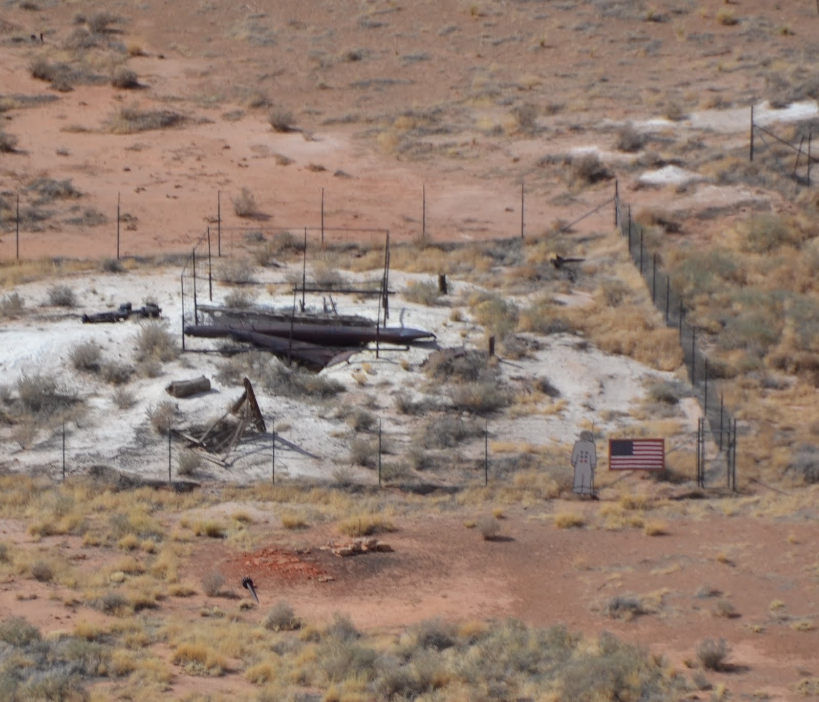
The actual base of the crater is closed off to the public, although some of the old investigative equipment is still there, though hard to make out. On the fences around it (next to the American Flag) they helpfully put a lifesize astronaut to help with the sense of scale. I've zoomed in for this picture--it's practically impossible to spot with the naked eye unless you know it's there.

There's a helpful telescope at the highest vantage point to find it and also to look around the desert plain. It's easy to see why this crater remained untouched and so well preserved.
Aside from a gift shop, that was about all to be seen when we went, but they were under construction to improve the site and its amenities, including adding a children's playground. Even so, I can't imagine seeing this would take longer than a couple of hours, so it should be scheduled as a half-day activity.
We carried along the I40 to Holbrook, near which the Petrified Forest National Park is situated. Please note, it's a fairly boring stretch of road, but it does run alongside a railway for most of the trip, and chances of spotting a train are good (we saw three or four). Meanwhile, Holbrook seems to be full of dinosaur models.
The Petrified Forest is not really a forest but rather the fossilised remains of trees that were swept downriver until they ended up in what is now a desert. Unfortunately, most of the fossils and more attractive pieces of wood were removed from the park before the administration started protecting it. Now taking wood from the park will land you with a heavy fine and it looks like there are random security checks as you leave. There is plenty of petrified wood for sale that was collected from areas outside the park if you want one as a souvenir.
 |
| Petrified Forest |
The Park has two entrances: the northern one is directly off the I40, for the Southern, you turn off at Holbrook and travel several miles down the 180. We entered through the Southern and drove through the park to depart from the Northern. The drive is beautiful, so my advice is definitely to do it. In which direction is up to you. The layered formations known as the Tepees were the highlight for me, but watch out for the tiny stretch of Route 66 that's been preserved within the park, marked by a vintage car.
 |
| One of the Tepees |
We opted to start with the Southern Entrance because it had the Rainbow Forest Museum, though this turned out to be much smaller than we expected (really it's just a room with some dinosaur bones in). Through the museum you have access to the short and easy Giant Logs trail, which goes around the biggest concentration of petrified wood in the park, including their biggest piece: Old Faithful.
The trail is paved but has steps, which makes it awkward for a stroller. There are leaflets available for a self-guided tour of the trail, under the cheerful system of take and return, or donate if you want to keep it. Should you want to extend your walk, the trail connects onto a longer trail at Old Faithful, though the leaflets don't cover that one.
 |
| Old Faithful |
We did the trail, but didn't try for the short film or tour. Just across the road was a gift shop, which had a few tables at which you could eat the snacks it sold, but there is no real eating place down this end of the park. The Northern Entrance visitor's centre is more nicely laid out with a proper restaurant, though that is for lunch only and closes in the mid-afternoon.
On the whole, this wasn't as good for children as I was hoping. You're not supposed to climb on the petrified wood, so as far as they were concerned, we were just walking around looking at rocks. While it was surprising how many colours you can find in a fossilised log, it wasn't really something our children appreciated.
There are numerous short trails suitable for children at least. We made the arbitrary pick of the Crystal Forest trail, as our breakpoint on the drive through the park. This was named for the crystals that had formed inside the wood here, but sadly the vast majority of these were taken by tourists decades ago, so while you can see some sparkly bits if you look, the trail's name is something of a misnomer nowadays.
 |
| I'm not entirely convinced by the 'forest' half either. |
The trail is entirely stroller friendly, with no steps whatsoever--lots of up and down, but nothing particularly steep.
One thing to bear in mind is that, as short as the trails are, you are in a desert. The day we went was overcast, so we weren't as conscious of the heat as we might have been otherwise, and I didn't have any water on me as I walked with my two year old daughter. I was fine, but after my daughter had half-walked, half-been-carried around the trail, she was breathing heavily and asking for water over juice. (Though after she'd taken several gulps of water, she demanded the juice as well.) In this instance, it was nothing that liquids and an air-conditioned car couldn't fix, thankfully.
Speaking of desert, the north end of the park has several attractive overlooks onto the Painted Desert. Apparently this is at its most attractive during sunrise and sunset, which wasn't really an option for us, but we still found it impressive.

Sunset Crater Volcano National Monument
After our second night in Flagstaff, we checked out and headed northwards up the 89. This would be our longest day of driving, since we intended to cover over 200 miles, but our first stop was just half an hour up the road, at Sunset Crater. This whole area is part of the San Francisco Volcanic Field, and Sunset Crater is the youngest of the cinder cones, erupting about 1,000 years ago.
 |
| Lava Flow with Sunset Crater (I think!) in the background |
Due to erosion, you cannot hike up Sunset Crater, but you can hike up Lenox Crater which is an almost unmarked trail opposite a turnout looking over the lava flow. This trail is short, barely a mile round trip, but it's fairly steep and it's a cinder path. It's not as bad as climbing up sand, but it's significantly worse than gravel. Going back down is physically easier (the cinders cushion the impact of each step nicely), but you have to be careful not to slip. Mind you, our four year old son was vastly entertained by the fact he was sliding onto his bottom every five steps.
Still, he managed to get up and down without particular trouble. Our two year old was having a meltdown before we even left the car, so I ended up carrying her and her suitcase which she insisted on taking with her. And by carrying her, I mean on my hip. We are not hardcore enough to have proper toddler-toting backpacks. I managed the hike comfortably enough, so this is definitely classed as do-able even for young families.
Be warned though, the crater at the top might come as an anti-climax, since it's long since been eroded away. We found ourselves on a flat area covered with more cinders and a couple of signs warning end of trail, do not go further. It was very windy and exposed--yet the trees serenely growing out of the cinders blocked most of the view, though we did get a nice shot of the San Francisco Peaks.
 |
| Lenox Crater's 'crater'. |
Even though I'd warned our son about this, he was disappointed that it didn't look remotely like the volcano on Jake and the Neverland Pirates. Then I explained to him that the cinders were essentially pieces of lava, and that cheered him up and started him playing in them. While it wasn't particularly dramatic, we still climbed a volcano, and we're not going to get many options to do that before the kids are much older!
Much more exciting was the old lava flow. I knew it was there, but I wasn't expecting the scale of it. It's like stepping into a post-apocalyptic wasteland--which, really, is exactly what it is.
A little further on from Lenox Crater is the better-recommended Lava Loop Trail, which has a small paved trail overlooking it for the stroller-dependent--though as our daughter was still having a meltdown, I couldn't get her to do even that. There's an information station there and leaflets for a self-guided tour should be available, but because it was so early in either the day or the season, there were none when we were there.
Our son (who loves to play the hot lava game) was thrilled to bits though. He did the paved trail with Daddy while I sat with our daughter, then he came to show me around, except he pulled me down onto the mail trail which goes out onto the lava itself. We only went a short way along it, and then I brought him back to the car and told my husband to go out and experience it too, because it was just so awe-inspiring.
 |
| I do not have the photographic skills to do it justice. |
Dinosaur Tracks at Tuba City
Let's be frank, there is precious little going up the 89 towards Utah. The highlight of that stretch of the road for me were the tumbleweeds blowing across it. (I got far more excited by these than anybody else in the car by a long way.) Once you get past Cameron, the scenery starts picking up a bit thanks to the Painted Desert, and there's a nice bridge across the Little Colorado River, but not much else.
However, through diligent googling I had discovered the Tuba City Dinosaur Tracks. Turning off the 89 onto the Navajo Trail towards Tuba City, there is a turn off on the left to a Dinosaur trackway. A lot of the reviews I found talked about missing the turn, but it seemed well-signed to us. Even if you don't see the sign, the giveaway is a central turning lane appearing in the road. We followed this smaller road a short way to where several cars had pulled over in an unpaved car park. A Navajo woman waved us into a parking space and got us set up with a guide.
 |
| Walking in the footsteps of Dinosaurs |
At the end, in lieu of a gift shop, we were shown to the tables of handmade Navajo items, mostly jewellery both traditional and modern in design. They aren't related to the dinosaurs, but there's some beautiful stuff there if you want a souvenir related to the local people.
For our children, who love Dinosaur Train, this experience of palaeontology should have been perfect. We were undone by the wind. The plain's very exposed and though it's probably baking hot on other days, we were getting regular blasts of cold air, and neither child appreciated it. We had to get through the tour as rapidly as possible. It was less than half an hour (maybe it would have been longer had we been more interested in loitering and taking pictures) but the children were relieved to get back to the shelter of the car.
That said, there's something very special about seeing dinosaur footprints on the actual ground where they once walked (as opposed to on exhibit in a museum). We didn't tell the children that the alleged T-rex footprint was actually far too old to be T-rex; it still came from a bloody huge carnivore, so why quibble? And we all had fun trying to match the strides of some of the smaller dinosaurs.
 | ||
| The sat-in-the-T-rex-footprint photo opportunity. |
From Tuba City, you can carry on towards Monument Valley, which is something I was sorely tempted to do, but I abandoned that idea due to time constraints.
Why we missed Page and Lake Powell
When I originally planned our itinerary, back in January, the intent was to drive up the 89 and cross the Colorado River at Glen Canyon Dam, near Page. However, when we did the trip, we found that signs telling us to detour through Tuba City to get to Page. It turned out that a landslide had destroyed part of the 89 in February.
Obviously, we were going through Tuba City anyway, but part of the reason I had wanted to take the 89 up that way was because it goes into the north end of the Grand Canyon, before dividing. The 89A takes a scenic route across the Colorado river before climbing out near (comparatively) the North Rim, while the 89 itself climbs up the cliffs on the east side. It was on those cliffs that the landslide had happened. The 89A was still accessible.
In the end, we decided that we were more interested in the scenery around the Colorado River and opted to take the 89A over the more travelled path via Tuba City and Page. The only thing I had wanted to stop and see at Page was a viewpoint shortly before you entered it: Horseshoe Bend. This was reputed to have no fence which would have required watching the children, but the online pictures are just gorgeous, and I'm still disappointed I didn't get to see it for myself.
 |
| Horseshoe Bend is somewhere upstream |
Lake Powell, which was formed by the Glen Canyon Dam is a recreational area, and if the children had been just a few years older, we might well have chosen to spend a few days here. Among the activities on offer were half-day rafting trips into the Grand Canyon (though not far into it; you need multiple days for the proper experience), and boat trips (two hours) to see the Rainbow Bridge.
Navajo Bridge

The 89A contained a pleasant surprise for us in the form of the Navajo Bridge, which crosses the Colorado River at a height of 470 feet. Clearly, I'd known we were going to cross the Colorado River, but as I hadn't researched this route, I had no idea what the bridge was like. In fact there are two bridges, as the original crossing was deemed insufficient for the traffic and could not be adapted. While a second bridge was built for the road, the first remains as a pedestrian bridge and there's a visitor's center on the west side.

Though our daughter had fallen asleep, our son had been clamouring to get out of the car for about five minutes, so we parked on the east side (which has few amenities beyond some shade and the omnipresent Navajo sales tables), and my husband walked him across the bridge and back. Then I walked across with him while my husband drove the car over. My daughter woke up when he parked, so we all had a look in the visitor's center, and then we had a scramble up some small cliffs by the carpark. That was just for fun, but it resulted in my favourite picture of the trip.

Journey to Bryce
From the Navajo Bridge, we continued driving on 89a through the canyon. At this point, it really just looks like a vast flat plain circled by cliffs. You can't see the Colorado River, because it's cut another canyon, Marble Canyon, which is mostly invisible from the road. There are some impressive boulders from rock slides, but otherwise, it's a long straight drive. Climbing out of it is a lot more entertaining, and certainly much twistier.
Once out of the Canyon, we passed the road that leads to the North Rim, which is still closed at this time of year, though it opens at some point in the spring. We crossed the border into Utah where we rejoined the 89 proper at Kanab. At one point, I had considered stopping in Kanab, but we were doing well for time and the children weren't fussing so we decided to push all the way on to Bryce.
After all the desert of Arizona, the silver green of Utah was just hypnotising. I couldn't stop looking at the streams babbling past the road. It was a great relief to be in a place that felt so alive--clearly, I am not a desert person.
A word of warning for this stretch of road... Make sure you've got the petrol (gas) to get through it. We were getting low on gas as we passed through Kanab but kept going, satisfied that we had a few towns coming up. These towns were all small, and we passed over the first gas station we saw as being too expensive. Then we discovered the remaining towns either didn't have gas stations or they had closed down. Luckily, our tank held despite the road climbing steadily, and we finally filled up just a few miles from Bryce.
One of the things we couldn't do but would have loved to try was the Red Canyon cycle trail, which runs alongside highway 12. I hadn't found mention of it while researching the trip, but we saw it as we passed through Red Canyon Park. Unfortunately, all the bike rental places seemed to be closed still from the winter. Even going by car, this was a beautiful stretch of road, featuring two sandstone tunnels to drive through.
We stayed in Bryce which was full of touristy things to do, all of which were closed. The tourist season starts later in the mountains of Utah than it does in the deserts of Arizona. Go figure.
NB We also changed timezones in Utah, losing an hour. Since we were only going to be in Utah for a couple of days, we kept our routine on the Pacific timezone for bed and mealtimes (though we changed our watches to keep attentive to opening and closing hours).
Bryce Canyon National Park
I had not anticipated the difference in climate between Bryce Canyon and the Grand Canyon. It was the most northern of the places we visited and high in altitude so I knew it would be colder--I didn't realise how much colder! We were lucky in that it was a warm day when we were there so the light layers of clothing we had were suitable. Two days later it was forecast snow again!
Bryce Canyon was the place I had most been looking forward to seeing, after viewing The Piano Guys' music videos. I had been very taken by the amazing towers of rock called hoodoos.
The trail that got the most recommendations for children was Mossy Cave Trail, which is technically outside the park, going through a small canyon to a waterfall. However, I was more tempted by the Queen's Garden / Navajo Loop trail, which takes you into Bryce Canyon itself and is three miles long (plus a half mile walk back along the rim to where you left the car). At three miles, it was going to be tough on our son and impossible for our daughter, and the trail itself wasn't stroller friendly... on the other hand, it wasn't so far that we couldn't carry them for a good portion of the trip, and we had no reason to rush.
Long story short, we did it. Our mistake was doing it so late in the trip. While our son had been eager to walk the day before, he was clearly reaching his endpoint when it came to trails. Also, we'd packed a picnic to eat on the floor of the canyon, with a view towards resting before we went back up, and our son spent a good twenty minutes asking if we could have a picnic now (despite being given the snack that I'd packed in anticipation of this very problem). Our daughter was as reluctant to walk as ever, and because I wanted to keep myself fresh for carrying her back up, I was reluctant to carry her, which led to a lot of wailing.
But we did it!
 |
| View from Sunset Point |
We started at Sunset Point, going down the Navajo Loop, which was steeper than the Queen's Garden trail. Though the scenic recommendation was to take the Wall Street (a slot canyon) side of the Loop, that was still closed for the winter. The view was certainly nice the way we took, but I can't vouch for what we missed!
Our daughter at least started off walking by herself, but it's an unpaved trail, with some loose gravel, and after slipping over a couple of times, she decided she wanted to be carried. Note that the dust of the trail is very orange and does a good job of grinding straight into clothing. Her white leggings showed it beautifully!
 |
| Heading down the switchbacks on the Navajo Loop. This was how I did half the road trip: with child on hip. |

Our daughter refused to enjoy anything about the trip, but these were a great distraction for my son. It took us a good ten minutes before we were past them (admittedly, we went slowly), and it was fun to see how some people had tried to outdo the rest by building in trees.
There were also plenty of larger rocks, perfect for child-climbing opportunities, and my son was ready to take advantage of these after we had finally had that promised picnic!

The Queen's Garden is so named for a formation that looks like Queen Victoria as she was depicted in portraits at the time.

Queen Victoria comes at the end of the trail, with a sign pointing her out. Beneath her is a gravelly set of inclines around her hoodoo and a few others. There is a mini-trail running around this, which is quite difficult due to the looseness of the gravel. On the other hand, if you do slip, you're just going to slide/roll gently down into vegetation and it seems improbable that you'd come off with worse than scratches.
My husband did it alone, and he was dubious that our son could manage it, but he wanted to give it a try, so I took him. Fortunately, I have an excellent sense of balance, and my son was very good about listening to my directions on where to put his feet, but I essentially had to lift him across one slippery bit of path, while stepping as carefully as I could. How we didn't tumble all the way down, I've no idea!
 |
| View from the hoodoo trail. |
Once we were done with this indulgence, it was time to climb back up. I did, as I'd feared, have to carry my daughter the entire way, putting her down only to rest. That was an endurance feat. My husband was fully occupied in coaxing our son up... though the Queen's Garden is a relatively easy climb out, it's a long ascent, and just when you think you've reached the top of the switchbacks, you round a corner and find some more. When you do finally spot the railed terrace at Sunrise Point ,it's still depressingly high above you. You may or may not suffer from the altitude as well.
Because we were both fully occupied with the children, we don't have many pictures of this climb, but you get to go through some sandstone tunnels and a mini slot canyon, and I found it a more interesting path than the Navajo loop, though the view could not rival the one at Sunset Point.
Up at the top, we walked along the rim trail, which like the Grand Canyon is paved, with some glorious views. I was exhausted, but I walked with our son, encouraging him onward while my husband carried my daughter and Facetimed his mother. (Who says men can't multi-task?)
Afterwards, we took the scenic drive through the park, gradually winding higher and higher, spotting deer near the start and snowdrifts near the end. There are several turnouts for views, but we only stopped at the one for the Natural Bridge (technically a natural arch) before we reached the end of the road at Rainbow Point, 9,000 ft above sea level.
 |
| Snowdrifts at Rainbow Point |
My daughter refused to get out of the car again, but my son played in the snow and jumped off some rocks at Rainbow Point, before we headed back down and out of the park, heading back towards Kanab.
We were planning to take the turn to Zion Canyon, which was the following day's destination, but at the last minute we decided to take a short detour to Coral Pink Sand Dunes. Google Maps claimed this would be a forty-five minute drive each way, but it was only about twenty, after we turned off the 89.
Coral Pink Sand Dunes isn't a national park, so we had to pay entry (which I think was $6). It's another desert, but what distinguished it from the others we'd visited was the vast amount of sand dumped there by the wind which had come through the sandstone cliffs. This makes it look more like a Sahara-style desert... just smaller.

There aren't much in the way of trails at Coral Pink Sand Dunes (though there are some). Instead, 90% of the park is dedicated to All Terrain Vehicles and the visitor's center points you in the direction of the rental. You can also rent various sandboards--I saw a couple using a snowboard-style one and a family using a sled-style. We didn't actually investigate the rentals ourselves since we weren't planning on staying long, but I kind of wish we'd got a sled.
The reason we went though is because I thought my daughter would like it, and I was feeling bad that she wasn't enjoying the trip. I was right... she adored the sand. The fact that we could just get out of the car, climb over a dune and play was perfect. The sand is a gorgeous colour (and made our already Bryce-dusty clothes even more orange) and is soft and fine. Just lying down in it is a treat. The children rolled down the dunes and threw the sand and were in heaven.

The soft sand is difficult to climb up (giving me new appreciation for the Sahara), and my daughter couldn't manage it at all, though she was perfectly happy just sitting in it. The wind was strong the day we went, and because it picks up the sand so easily, that's a problem with small children, but once we sat down on the other side of the dune we were completely sheltered from it.
There are picnic tables, a deck overlook, and a grill the day we went. I imagine on a busier day, there would be lots of entertainment from the ATV's, though probably also a lot of noise. The visitor's center had a live snake on exhibit and my son got to see it being fed, which excited him. He didn't actually see it eat, just the mouse running around and the snake being a bit docile. It didn't upset him in the least--I imagine that if you have an issue with such things, you can ask the staff to wait until you've left the building!
 |
| One of the local wildlife |
The sand dunes by the visitor's center weren't completely barren so didn't really lend themselves to sandboarding or more dramatic vistas. However, before you enter the park itself, there is a carpark with an information board. Climbing over the sand dune there, we discovered a much emptier sweep of dunes to play on.
 |
| I was halfway down the slope taking this picture and had a big struggle climbing back up. |
Springdale
When we were all done playing in the sand, we got back on track for Zion. We were staying in Springdale, which required driving through Zion National Park first. Our pass gave us free entry anyway, but I believe the standard entry to Zion is valid for seven days, so it's no problem to drive through the evening before your visit.
We all enjoyed the drive. The sloping, rounded rock formations outside of the Canyon were particularly attractive--inside the Canyon, the rocks are different, so if you want to get hands on with the curvy ones, find a stopping point before you enter the tunnel.
A long tunnel takes you through the mountains and out onto the switchback road down to the floor of the canyon. The tunnel is deceptive, since there are numerous 'windows' along the route, making you think you can see the light of the end. While these windows offer tempting views, you are not allowed to stop inside the tunnel nor to walk through it.
After driving through the Canyon, we exited the park and found ourselves in Springdale almost immediately. We could only stay for one night, but we would gladly have spent longer here. Springdale is very pedestrian friendly, greener than the Arizona Deserts, but warmer than the high altitudes of Bryce. The free shuttle service within Zion Park goes along the main (hotel-lined) road of Springdale too.
After we'd checked in, we took a stroll along the road. For the record, we ate at the Flying Monkey which had a very limited children's menu (pasta with cheese sauce or pasta with marinara sauce), but we entered with a screaming two year old and they didn't bat an eye but set us up at a quiet table and brought the children water immediately. The food was delicious too.
Zion Canyon
The difference between Zion and the other parks we'd visited was that the scenic road was closed to ordinary traffic at this time of year, forcing us to take the shuttle (this also makes it great for cyclists). While there is some inconvenience to taking the shuttle (you have to be packed with all you need for the day; you're restricted to the shuttle's pace and schedule), this was really very easy and we never had to wait more than a few minutes. I wish now that we'd explored the other parks' shuttle options.
The universal recommendation for children in Zion was to go and see the Weeping Rock. This was up a steep but fully paved and short (half a mile) trail. You could get a light stroller up there, but it's so short that I got my daughter to walk, pulling her rolling luggage behind her, and I only had to carry her for the last few yards. There is a small flight of steps right at the top between a viewing area and the area underneath the overhang.
The Weeping Rock is an overhang that is dripping with water that has apparently taken 1000 years to filter through the sandstone. On a sunny day, the fascination of finding a rainy spot was irresistible for the children, even for my trail-phobic daughter.


Be warned, it's a little muddy and slippery beneath the weeping rock (though the area has a shallow wall and you're unlikely to fall off the edge). There are several puddles and our toddler did indeed get blissfully wet from splashing through them.

If I'd had no restrictions, I would have loved to have hiked up the Narrows, where the walls of the canyon close in around the river, obliging you to walk in the water. However, this would have been beyond our children's capabilities. As a compromise, we decided to take the Riverside Walk, an easy mile long trail that leads to the Narrows.
 |
| Gateway to the Narrows |
For us, the Riverside Walk was really a huge mistake. Neither child was interested in yet another walk, though they loved playing in the river at the end. We'd have done better to just go to the river at the start, building dams and scrambling over rocks there.

Still, if you haven't got children who are sick to their backteeth of hiking, it's a lovely walk and a lovely beach at the end (though crowded even at this time of year). The water was cold, so we didn't do more than light paddling. At a warmer time of year and with slightly older children, we'd probably have waded a little further to look at the Narrows themselves.
While we saw plenty of people going barefoot as they played in the river, the hiking advice was to wear close-toed shoes in the river (and check for flashflood warnings). The Zion Adventure Company in Springdale rents out a full outfit for hiking in the river, and we saw one family setting off in these, the youngest looking to be about eight. This, more than anything else on the trip, is something I'd like to come back for.

Due to the children being over-tired, the Riverside Walk took longer than we had anticipated and it was well past noon by the time we got back on the shuttle, so we left the park, stopped for a quick lunch in Springdale and headed on the road back to Vegas. Both children slept for a good couple of hours in the car, so we did a non-stop drive with no need to look for distractions.
All things being equal, I would have probably liked to stop in St George, maybe hunt down the Piano Guys' piano shop, but we always knew this trip was going to be an exercise in missed opportunities. The important thing was that we did take the opportunity we had to see it, and while there was much we couldn't do, there was always going to be too much to do.
Even keeping within the capabilities of our small family, we still had a holiday packed full of amazing experiences, and every day we were doing something we'd never done before. A dream holiday indeed... and we still had a week in Vegas to go!
No comments:
Post a Comment